K'gari (Fraser Island)
K'GARI
HIDDEN GEMS
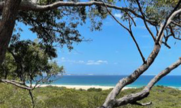
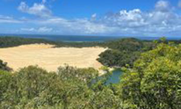
Lake Wabby & Hammerstone Sandblow
Lake Wabby is a green freshwater lake which sits adjacent to the Hammerstone Sand Blow. It is a beautiful lake to swim in after the walk across the sand blow. Make sure to bring your camera. You will want to take a photo of vast sand blow against the surrounding forest and ocean in the distance. Lake Wabby is the deepest lake on the island and has more than 12 species of fish. The lake was once a coastal creek leading to the ocean. Over time the migrating sand has blocked the creek and a lake was formed. This is known as a Barrage Lake. It is estimated that it will take just over a century for the migrating sand to gradually consume the lake.
In the past, Lake Wabby was popular for body boarding down the sand dune into the lake. However, this is not recommended now as many visitors were injured when they misjudged the depths of the emerald water close to the edge. Instead, sit quietly and wait for the large catfish to arrive. Kids and adults love to watch them swim slowly by.
There are two access points to the lake. You can start inland at Lake Wabby Car Park and make your way down to the lake. This route is approximately 3.1km return and has a viewing lookout. You can also access the lake by hiking from Seventy-Five Mile Beach over the sand-blow to the lake. This walk is 5.2km return and is best done in winter when the sand is not too hot underfoot.
TIP: In summer or on warmer days we recommend visiting from Lake Wabby Car Park. In the cooler months it is well worth the extra 2km to visit from the beach side.
FACILITIES: Toilets at Lake Wabby Car Park (inland access point)
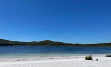
Lake Birrabeen
While Lake Birrabeen’s water isn’t quite as clear as that of Lake Boorangoora (Lake McKenzie), it still has beautiful white sand beaches and freshwater. If you want to avoid the crowds and spend a quiet day relaxing, we recommend visiting Lake Birrabeen. It’s where the locals go. Along with Lake Mckenzie, Lake Birrabeen is believed to have the freshest water in the world. Perched lakes consist entirely of rainwater and are not fed by creeks or streams. Overtime organic matter and sand compresses to make an impenetrable layer where rainwater cannot escape. The size of lake Birrabeen makes it ideal for kayaking and paddle boarding.
FACILITIES: Toilets
Lake Boomanjin
Close by to Lake Birrabeen is Lake Boomanjin. It is the largest perched lake in the world, covering 200 hectares. This lake has a reddy/brown hue due to the tannin from the trees surrounding it. This tea tree lake may appear murky but it has incredibly fresh water and your hair and skin will feel great after a swim due to the tannins. Families with young children especially enjoy this lake as it is shallow for quite a distance from the beach. Nearby is a dingo-fenced day use area with picnic tables. It is a nice spot to enjoy lunch in the shade of the gum trees.
FACILITIES: Toilets
Lake Allom
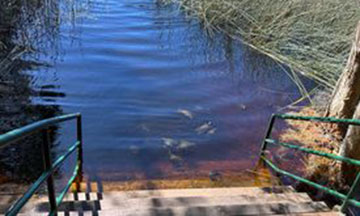
Lake Allom, more commonly known as the ‘turtle lake’, is a perched lake sitting in the middle of lush rainforest. Take a short walk through the rainforest and down to the lakeside. If you sit quietly at the lake’s edge, freshwater turtles (Emydura Krefftii) will poke their heads up in the shallows. They come right up to the stairs leading down to the lake. This is a must-see for families with children. Swimming is permitted in the lake, but you might want to save your swimming for a clearer, less reedy lake.
TIP: Lake Allom is located on Woralie Rd. The entrance to Woralie Road from Seventy-Mile Beach can be very soft. We recommend taking a run up to the track, so you have enough momentum to cross over the soft sand without bogging.
FACILITIES: Toilets
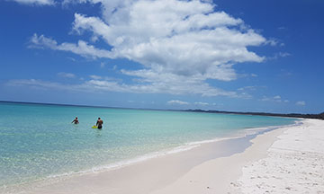
Moon Point
Moon Point is a pristine beach on the western side of the island. Pure white sand borders turquoise water for truly picturesque photos. Sea turtles and whales have been spotted in the right season. Spend the day paddle boarding, fishing, swimming or just relaxing on this pristine beach. The drive to Moon Point passes through Yidney Scrub, which has some of the densest rainforest on the island and our favourite drive. Make sure to stop and take a photo inside the huge strangler fig.
TIP: Avoid visiting Moon Point at high tide, to avoid parking in very soft sand. We also recommend avoiding Moon Point when the wind is blowing from the west. The pristine beaches and calm bay will turn rough.
TIP: If the island has experienced several days of heavy rainfall, the Moon Point Road can become impassable due to inundation of the track from surrounding swamplands.
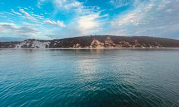
Platypus Bay
Bowarrdy Creek, Woralie Creek, Awinya Creek and Wathumba Creek all flow into Platypus Bay. This beautiful bay is where Humpback whales teach their calves to swim. It is ringed by white sand and solid sand dunes known as Arch Cliffs. Take a photo with the iconic Palm tree on the island and soak in the beautiful landscape. Make sure to check tides before traveling as the beaches are narrower on the western side and Awinya creek can be difficult to cross at high tide.
TIP: Visit Lake Allom on the way to Platypus Bay
Waddy Point
Waddy Point is a headland just north of Indian Head and Middle Rocks (Champagne Pools). Pockets of water (lagoons) form on the beach making it an ideal place to swim or float around. It is a great place to put out an awning and spend the day fishing, swimming and relaxing. You can also go sand boarding on the nearby sand dune called “Big Mumma”. Go exploring around the headland for small rock pools which contain sea creatures. Nemo’s (Clown fish) can be found in some of the pools on a very low tide.