K'gari (Fraser Island)
MUST SEE
ATTRACTIONS
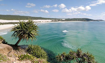
Boorangoora (Lake McKenzie)
The only area in Australia which have a higher concentration of lakes than K’gari is Tasmania. Forty of K’gari’s freshwater lakes are perched in the tops of sand dunes high above sea level. This is remarkable given that there are only 80 such lakes in the world. K’gari also supports the largest perched lake in the world, Lake Boomanjin at 200 hectares, and the highest altitude perched lake, Bowarrady, 120 metres above sea level. However, the 130 ha Lake Boorangoora (Lake McKenzie) is by far the most popular and arguably the most picturesque.
Lake Boorangoora is the most famous of all of K’gari’s attractions. Notable for its size, its crystal clear fresh water, the surrounding pure white sand on its beaches and the peacefulness and tranquility of the area, Lake Boorangoora is an ideal place for swimming and picnics with its clean white sands and crystal clear blue water.
Central Station
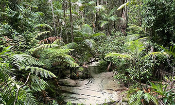
In the heart of the rainforest, Central Station is so named because of the establishment of a central Forestry Department station which operated from 1920 to 1991, when the island was logged. Many cottages were built during this time for the workers, the remnants of which still stand today as a reminder of this period. This is now one of the most popular scenic areas on the island, containing story broads (check if storyboards are still there) and information panels on the European logging history of K’gari. Don’t leave until you check out the short walk down to the pristine Wanggoolba Creek. You will find the entrance behind a stand of magnificent ghost gums. (Facing away from the car park, you will see them on your left).
Many magnificent pockets of rainforest are dotted throughout the central southern section of K’gari. The valley formed by Wanggoolba Creek near Central Station contains magnificent trees - huge kauri, rough barked satinay, brush box, hundreds of airy piccabeen palms and many more push upwards towards the sun, which is so thick in places that its light struggles to penetrate the forest canopy.
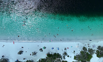
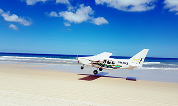
Seventy-Five Mile Beach
There’s nothing like the feeling of freedom you experience while driving along Seventy-Five Mile Beach. Most people are unaware that Seventy-Five Mile Beach is a registered National Highway. Like the name suggests, Seventy-Five Mile Beach is 120 kilometers of beach which runs from the bottom of the island and all the way up to Indian Head. It is known for excellent fishing, the SS Maheno Shipwreck and the beautiful Eli Creek. It is not recommended to swim off the beach due to strong currents.
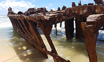
The Wreck of the SS Maheno
The SS Maheno was built in Scotland in 1905 and was originally used to ferry passengers between the east coast of Australia and New Zealand. In 1915, it was used as a hospital ship to bring casualties from Gallipoli to Malta during World War I. In 1935, it was decommissioned and sold to a Japanese company for scrap metal. Three days after being sold, the Maheno was under tow to Japan when a powerful cyclone caused the tow rope to break. The Maheno washed ashore on Seventy-Five Mile Beach. The wreck is one of the island’s most photographed attractions, beautiful on a clear day or shrouded in a seamist; stunning at sunrise and sunset. Just remember to check your tides when planning your trip.
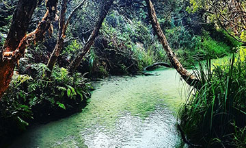
Eli Creek
K’gari sits on top of a huge underground reservoir of fresh water. Much of the 1800 millimetres of rain the Island receives each year, filters through the sand until it is held by the rock base some 30 metres below sea level. As a result, there is an abundance of natural springs feeding freshwater streams that ceaselessly pour into the Pacific Ocean to the east and Hervey Bay to the west.
In one 30 kilometre section of the famous Seventy-Five Mile Beach, 200 creeks run into the Pacific Ocean; some large, some appearing as wet sand from foredune to surf. The largest and most attractive on the eastern shore is Eli Creek, which originates many kilometres inland and pours eight million litres of water a day into the Pacific Ocean.
This creek is very popular with families, providing safe water for swimming. It has long been the custom to float down it on all manner of personal flotation devices, so don’t forget to pack your blow-up rings. This is nature’s water park. Once again though, make sure to check your tides.
Indian Head
One of the few genuine rocky outcrops on the island, Indian Head is at the northern end of the K’gari’s famous Seventy-Five Mile Beach. Once it becomes visible, on your drive north along the beach it appears to take forever to reach it. Visitors climb to the top to take in possibly the best panoramic vista of K’gari’s beaches. On clear days, you can see manta rays, sharks, dolphins and turtles swimming and hunting in the waters below. During whale season you have to be unlucky not to see the Humpback Whales passing by.
Please note, the walking track to the top of Indian Head is currently closed due to erosion. For updates please visit Queensland Parks Alerts page.
Champagne Pools
Champagne Pools are located just north of Indian Head, at the northern end of Seventy-Five Mile Beach. These pools provide a very popular swimming hole as the ocean waves tumble over the rocks into the pools. The foaming water is how Champagne Pools gets its name. Take a dip or relax and sunbathe at these very popular, naturally formed volcanic rock pools. Often you will be joined by small fish, so bring your swimming goggles.
It is the most popular salt-water swimming destination on the Island. There are timber walking tracks and steps to enable easier access. Stop before descending the stairs and take in the amazing sea views.
Please note there are extremely strong currents along this part of the island and swimming on the ocean side of the rocks is not encouraged. Caution should also be taken walking on the sharp rocks as well. We recommend wearing reef shoes when approaching and swimming in the pools.